I used to think I had a good sense of direction, but that was because I grew up in rural Iowa, where everything is laid out in a grid. The roads run straight north-south or east-west, and, generally, there is a road every mile. I was amazed when I moved to Indiana and then Wisconsin and learned that other rural areas did not do this, because of "hills" or "dairying" or whatever other excuses got in the way of rationality.
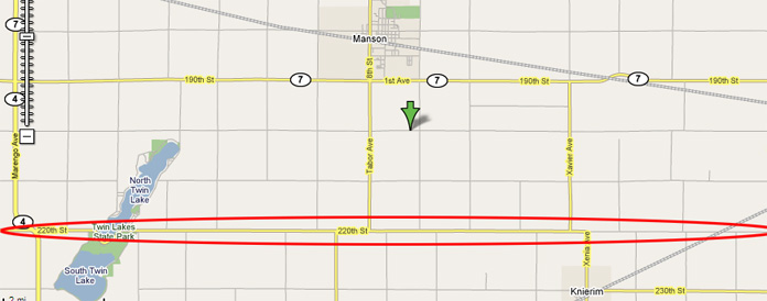
Anyway, the map above is the area where I grew up. The green arrow marks the Freese Family Farm. You can see the grid. But, if you look a couple miles south of where I grew up, you can see a road circled in red. And you can see that road is not like the others, because no north-south road crosses it. Instead, if you are driving south, you need to go east or west for a bit, and then you can head south again unperturbed for miles. The road is called "220th Street", but that's a convenience for implementing 911 service and no one actually calls it that. Instead, it is often referred to as the "Correction Line." Quiz feature, for which any Manson-area readers are ineligible: Why is this road called the Correction Line? First correct and appropriately charming answer gets one of the coveted JFW virtual kewpie dolls.
When I was home last week, I got to tease my much older brother when I realized that he didn't know why the Correction Line was called the Correction Line. "You were in the Navy, right?" "And, when you were in the Navy, you got to sail to all the way across the ocean, right?" "And, I've never been in the Navy, so correct me if I'm wrong about this, but when you sailed across the ocean there was never any issue of your ship, say, falling off the edge of the world?" "And, so, did you get a sense these that the world might be--I don't know, just to throw out one possibility--sort of roundish in shape?"
15 comments:
a surveyor's "correction line" adjusts for the convergence of the meridian lines, which keeps the section boundaries approximately 1 mile apart, making all sections approximately the same size (approximately 1 square mile).
-sr
damn, i'm hour too late! i was going to say the same thing, which is to say: longitude lines aren't really parallel over long distances, due their convergence at the poles.
but it doesn't even matter now.
but i wanted a doll.
which, i should add, the roads that run N-S in iowa are akin to longitudinal lines on a globe, but they need to "correct" for curvature of the earth, hence the "correction" line.
One could also add that the idea that correction lines only occur along the boundaries of survey townships (every sixth one, I beleive) and that the method of selling surveyed square plots was laid out by the Land Ordinance of 1785 (only of only two significant pieces of legislation passed by Congress under the Articles of Confederation) and that places like Indiana and Wisconsin (and pretty much any place west of the Appalachians and north of the Ohio River) should also have similar square-grid road systems because they were surveyed under the same system and you probably just didn't get far enough out in the country to observe this.
Sal: I can't believe you Googled up the answer! But still, you get the doll, pending results of the performance-enhancing-drug test. Send urine ASAP.
Not only did he google the answer, but he quoted directly from it without attributing the source. As a professor at a major university, do you really want to reward this type of behavior (even if he sends the urine)?
I had never experienced the rural grid system until I was in Saskatchewan this summer. That's where I learned the irrationality of switching to the metric system, at least where a physical mile-based infrastructure already exists. You could easily tell if someone was a country person or a city person by whether they gave distances in miles (since every rural intersection was exactly one or two miles apart) or kilometers (the official unit of measurement that makes no sense given the mile-based grid system).
There's an aerial photo of a correction line on the front cover of Jim Scott's "Seeing Like A State". You'll have to do better with trivia. :)
Non-timed trivia contests are made impossible in an age of Google and steroids, regardless.
I have Seeing Like A State and totally forgot that it had a correction line on the front, even though it's a superb photograph of one. There's also a nice brief description of correction lines on the back.
AK: It's an interesting question as to whether, if the original surveying had been done in km, whether sections would be a square km. That seems to small--and that section road would instead be every other km, making a section 4km--although maybe that's me imposing my milecentric view on things.
Internet Dog, as someone who grew up far into rural Wisconsin I can assure that the roads there are NOT on a grid. Southwestern Wisconsin is unglaciated and very hilly so (Jeremy's snarkiness aside) building roads on a grid wouldn't make much sense. Do you really want to build a road straight over a hill when it would be easier just to follow the contures of the land? What's more do you really want to drive straight down a hill in an icy winter?
None of this would be an issue, obviously, if my idea of having west and east poles was adopted. Deciding their exact location was too difficult even for the United Nations.
I totally would have participated in this contest if you were giving away Kewpie, the Japanese mayonnaise. But a doll just isn't worth my time.
Much the same effect can be seen in the natural world where right- or left-lateral strike-slip faults truncate and offset drainages.
Not directly related, but related enough: I'm in Iowa and had to say hi from here.:-) Hi!
Post a Comment